

How Does Ram Mandir Look From Space? ISRO Satellite Captures Image
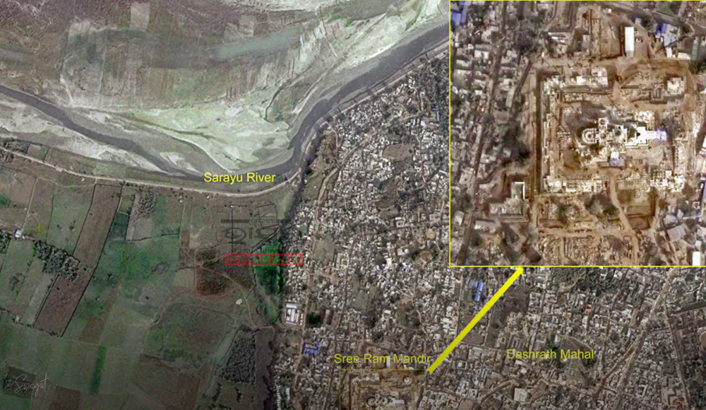

Ayodhya: Ahead of the grand consecration ceremony at Ayodhya, the Indian Space Research Organisation (ISRO) has unveiled the first glimpse of the majestic Ram Temple captured by indigenous satellites. The 2.7-acre temple site, including an enlarged view, was imaged on December 16, overcoming challenges posed by dense fog in Ayodhya.
The satellite images showcase Dashrath Mahal, the Sarayu River, and the recently renovated Ayodhya railway station. Utilizing India’s over 50 satellites, with some boasting less than a meter resolution, the National Remote Sensing Centre in Hyderabad processed the images. ISRO’s technologies played a crucial role in various stages of the temple’s construction.

One significant challenge was pinpointing the exact location to place the idol of Lord Ram within a specific 3 feet X 6 feet space, believed to be his birthplace. Following the 1992 Babri Masjid demolition, debris covered the site, requiring meticulous removal. Space technology, particularly the sophisticated Differential Global Positioning System (GPS), aided contractors from Larsen & Toubro in determining precise coordinates with an accuracy of 1-3 centimetres. These coordinates formed the basis for placing the idol in the temple’s sanctum sanctorum.
Alok Sharma, International Working President of Vishwa Hindu Parishad, emphasized the role of space technology in overcoming the challenges posed by the decades-long gap between demolition and construction. The GPS technology used also integrated signals from India’s ‘swadeshi GPS,’ the ISRO-made ‘Navigation with Indian Constellation’ (NavIC) satellite constellation.
ISRO Chairman S Somanath highlighted that five NavIC constellation satellites are operational, with plans for system upgrades underway. The convergence of space technology and religious heritage marks a significant milestone in the construction of the Ram Temple.
 Home
Home Videos
 Odisha
 Nation
 World
World Crime
Crime Politics
 Sports
 Health
 Lifestyle
 Business
 Education
 Entertainment
Comments are closed.